

Before leaving Shotley, a last visit to Colin and Katie Byford. Note their awesome caravan in the drive.
OK, contrary to the title of this entry, we didn’t sail any where near Hawaii, but bear with us for a moment.
We have been berthed in Shotley, in southeast England, near Ipswich, at the mouth of the River Orwell. After Hugh’s wedding, we’ve been waiting here for good winds to move south. We had been aiming to do a day sail, bound either for Ramsgate, about 50 miles away, or if the wind and tides would allow, all the way to Dover, 15 miles further south. Dover is halfway around England’s southeast corner, and so it would be a nice if we could start to make that turn.
We would be crossing the Thames Estuary. We’d done that once before, but each time is a challenge.
The mouth of the Thames is about thirty miles across. It is a true river delta, shaped by current-carried sediments and strewn with shifting sandbars. The dynamic nature of the area means that, like the dunes on a beach, the contour of the bottom is constantly changing, and even the most recent charts come with a warning that the cartographers are not capable of keeping up with the ever-changing sea floor.
There are a number of deep-water channels allowing passage among these sandbars, but through these channels must also ply the commercial traffic bound to and from the docks around London. Close attention must be paid when sailing in or crossing these channels. Because the Thames is tidal, and the tides in this part of England are significant, the currents through the channels and across the sand bars can be quite strong. If the wind blows against current, a good sized chop can set in, which can slow progress.
Also, to take advantage of the strong winds that blow here, a number of wind farms have been built in the estuary. Those must be taken into account as well. Because of these factors, we spent some time studying the charts, the shipping lanes, the tide tables, and the wind forecast so that we could try to time things right.
September 17 was a “go” date, with winds between 10-15 knots from the west forecast for most of the day, backing slightly west-southwest in the late afternoon. We left Shotley marina at 7 a.m. for what we’d been told would be about a nine hour trip.
When we got out of the River Orwell, we found that the forecasted 10-15 knots of wind was actually gusting to higher, and, except for the absence of the thick fog that enveloped us in an earlier passage in this area, we had all the makings for a difficult passage.
We timed our departure to take full advantage of flood tide, which would carry us through a good part of our journey. Our goal was to get around North Foreland, at the southern end of the Thames Estuary, before the current turned.
There are a number of route options, and we chose to sail down a deep water path known as the “Black Deep,” and then cut over to the “Knock Deep.” The cross-over between the two channels can either be done at “Fisherman’s Gat,” or a little bit earlier at “Foulger’s Gat.” Using Foulger’s Gat would take us right through the London Array Wind Farm, but as it would mean less time in the shipping lanes, and was supposed to be well-marked, we chose that route. (The authorities provide way-points for this shortcut, and the curving channel itself is marked by a buoy at the entrance, mid-way, and at the far end.) As we came down the Black Deep approaching the cut, the wind began to blow hard, now gusting to 25.
We made a hard left turn from one side of the Black Deep channel to cross over to the entry to Foulger’s Gat, about a mile and half away on the other side of the channel. As we got closer, one of the vessels working in the area appeared to be coming out to meet us, but then settled sideways across the entry. It was unclear what message they were trying to send us, as they flashed no lights and did not call us on the radio, and so we sailed on. They couldn’t really “block” the entry anyway, as it is several hundred yards wide. We entered into the Gat in very windy conditions, and sailed by the vessel, which took no action as we passed. (We later read that these work vessels some time try to “block” the entry of passing pleasure craft. In retrospect, this appears to be a particularly discourteous act, in light of the official written invite to use the cut. The practice, if it is that, can also be dangerous, because it can cause indecision on the part of a yacht transiting a shipping lane, when options to alter course are constrained.)
The Gat was not nearly as easy to navigate as the charts made it out to be. Even using our chartplotter, we found that on two occasions the path led us directly to the bases of the enormous wind generators. The supposed channel could definitely use some additional buoys. It was not too much of a challenge steering around the turbines, because the enormous blades turned above the height of our mast, but we held our breath as we’d read that there are cables that run to and from some of the installations. We couldn’t imagine that cables would have been placed at a shallow depth in the midst of supposed charted path through the wind farm, and so we pushed on, albeit with great care.

Up close and personal with a London Array wind turbine.
We finally cleared the wind farm and turn due south again, coming closer to the wind and aiming once again at our destination. The current and wind carried us along at great speed, and we made North Foreland quickly, arriving at just after Noon. The winds eased to 10-15 knots and the waters calmed as we neared Ramsgate about an hour later, such that the entire trip had been done in just six hours. Although the current was beginning to turn, we figured that even if we slowed to four knots, we could easily cover the final 15 miles to Dover before the end of the day. And so we carried on.
Bad idea!
The current reversed direction, as we expected, but the wind also began to rebuild, which we hadn’t expected. And as the wind built, it also backed southwest (which HAD been forecasted), at the same time that we began to turn southwest around the bottom corner of England. Before we began to make this turn, England was due west, and we were sailing in its lee. That made for relatively calm seas. When we turned southwest, however, and the wind backed southwest to meet us, there was no longer anything to shield us from the seas, and the swell began to increase in size. Maybe we could have anticipated what all of these factors would cumulatively mean, but we didn’t.
Within an hour, we were bashing into heavy seas. The boat speed was now hovering between two and three knots, and the motion was becoming quite uncomfortable.
We cranked up the engine to about 2000 RPMs, put a reef in the main (we should have put in two), and “motor-tacked” back and forth towards Dover Harbor. The harbor walls seemed tantalizingly close but, at our speed, were still a long ways away. Leander handled the seas OK, but began to shake her contents about, perhaps to remind us that she was happier on a beam reach in the calmer seas, thank you.
And now about that “Hawaii” reference. Ever seen pictures of those waves on the north shore?
As we closed on Dover, we were taking the seas just off of our bow, alternating from port to starboard as we tacked. But for the last part of the journey, we needed to turn sideways to the seas, coming close inshore to avoid the ferry traffic. We called Dover Port Control, and were given permission to approach the eastern entrance. (Dover is the busiest ferry terminal in all of the UK, and so traffic in and out is tightly monitored.) As we neared, one commercial tanker entered in front of us, and two high-speed vessels were closing on the entrance from the east. Leander was given permission to enter in front of the ferries, but encouraged to “use its best speed.”
So we did, but that last quarter mile was the most difficult. In the final approach, we were hit by a set of curling waves the likes of which we have not seen since Chincoteague Harbor. At least at Chincoteague, however, we got to surf DOWN the waves. These ones came at us from the side, and pushed Leander pretty far over, before allowing her to snap smartly up to present herself freshly for the next wave. Things went flying in the main cabin that have never gone airborne before, including the framed print of the HMS Leander, which we thought had been fixed solidly to the wall. (Now it is fixed MORE solidly.)
We made it safely inside. Thank goodness for an enormous entry in the harbor wall, as the wind, current, and waves were making it difficult to aim Leander very precisely.
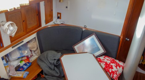
Cabinets flew open and the framed Leander print came loose from its wall mountings.

Some of the spice rack contents also went airborne. That’s mostly curry powder that got loose on the counter. We smelled like an Indian restaurant for the rest of the day.
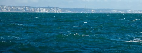
Just for comparison, this was the sea state a few days later, after things had calmed down completely. In other words, the currents stir up a significant chop even when there is little wind.
We found a berth, cleaned up, and surrounded by the white cliffs of Dover, had nice dinner and hit the sack.
Before we close this blog, a few comments about our stay in Shotley and our return to the River Orwell. (We had visited on our way up to Orkney two years ago.)
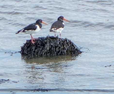
A pair of oyster catchers on a rock in Shotley.

With its distinctive bill, it wasn’t too hard to identify this fellow in our bird book. It’s an aptly named “curlew,” hunting for some breakfast.
We made some great new friends in Colin and Katie Byford. Colin works at Shotley Marina, and was great help to us in getting things done during our visit. He and Katie had us over for an evening meal, where we met their son Callum and Alexander and Aylin got to know their daughter, Libby.
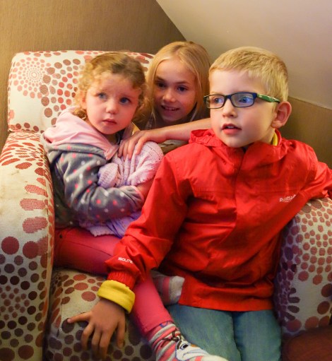
Aylin, Alexander, and Libby curl up to watch a children’s program.
We also got caught up with good friends that we made during our last stay here, as Tony and Brenda Read drove down the river for a long afternoon visit. It was good to see them, and for us to all catch up on goings-on since we’d seen them last. In typical Tony-and-Brenda fashion, they insisted on driving Sima and the kids all the way to Ipswich and back for an errand run, and stayed around in town to keep the kids entertained while Sima navigated the shoals of ensuring connectivity (sim cards) for our cell phones, tablet, and lap top.
Tony and Brenda Read with Sima and Alexander. (Cheer up Ari, or will find someone else to pose for all these photos!)
And last but never, ever least, we also caught up with our old friends Gus and Helen Wilson. We had wintered with them at St. Katherine’s Dock in London several years ago. Ever since then, Gus has been instrumental in keeping us in contact with the many other boats that we had gotten to know there, introducing us to other OCC port captains along our route, and giving us guidance in advance of the various stages of our trip.

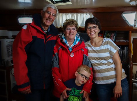
Paul and Alexander with Gus and Helen Wilson from s/v Wings.
770 miles traveled, zero miles to Dover, 370 miles to Brest, France, and the jump off point for the Bay of Biscay, 3,900 miles to the Caribbean.
The transit of the Bay of Biscay — admittedly that’s been on our minds for months. That will be for another entry.

Re your Thames estuary adventure, sailing is fun, often when said & finally done!
LikeLiked by 1 person